Snow Magazine snow reports in association with
![]()
We thought we’d seen the last of the Siberian weather systems, with seesawing freeze-points in the past week, but the cold returns to Europe this week, and fresh snowfall is on the way to the Alps.
Some significant snowfall also for the French Alps, parts of Switzerland, Italy and western Austria. As the new system sweeps in from the East, it will bring around 30-40cm of snow typically, but with the Italian resorts claiming the lion’s share.
With Easter not far off, expect a late flurry of activity as skiers try to make the most of what might be the last significant widespread snowfall of the season.
FRANCE
After the north west Alps got a nice 10cm top-up earlier this week, the snow keeps on coming in the winter that doesn’t know when to quit.
It’s back to the southern Alps for the big new snow in the week ahead, with a big dump tomorrow, a sunny interval on Friday and steady snowfall from Friday night bringing accumulations of up to half a metre for resorts such as Auron (100/170cm) and Isola 2000 (155/250cm).
Head further north through Les Deux Alpes (80/200cm) and Alpe d’Huez (215/340cm) and over the next few days the snow is a bit lighter but steadier, though mist comes into the picture too.
The North Western Alps too, can expect decent accumulations over the coming week with around 30-40cm due at Flaine (180/420cm) and Val d’Isere (290/435cm), and around 25cm at Avoriaz (270/385cm) and Les Arcs (150/400cm).
SWITZERLAND
After clear skies and sunshine today, it’s steady, sometimes heavy snow all the way for Zermatt (140/340cm), with around 60cm in all. That puts the resort top of the forecast-tree, but the pattern is broadly similar at Saas Fee (120/475cm) with up to 40cm due and at the Jungfrau resorts such as and Murren (110/415cm) though with only around 20-25cm due.
Quite a few Swiss resorts are reporting wetter snow lower down, including Verbier (100/340cm) and Davos (120/245cm) – which have anything from 10-20cm coming - so they’ll be happy that the freeze-point should be low enough to keep the precipitation as snow rather than rain.
ITALY
Anyone heading out to the Dolomites for a late season fling can expect to find some fresh snow, at least on the higher slopes. Up to 40cm is forecast to fall between Thursday and Saturday, which is good news for resorts affected by rising temperatures last week.
‘Fresh snow higher, wet lower’ has been the message from the likes of Cortina (40/130cm), Alta Badia (60/180cm), Arabba (130/160cm) and Canazei (50/130cm) but this week’s new snow may even refresh the lower slopes.
After a sunny day today, Prato Nevoso (180/350cm) again looks set to receive a truly significant dump of well over a metre, spread over the next six days, when it currently looks as if it will just not stop snowing!
It’s another snowy outlook at last week’s star San Martino di Castrozza (50/160cm), which is in line for at least five days of moderate to heavy snow, with just a slight respite on Sunday, as it adds another 60cm. And the Monterosa resorts can expect up to half a metre, too.
AUSTRIA
After a mild but unsettled weekend, Austria is in line for a mix of sunshine and snow showers this week, though the amount of fresh snowfall will mostly be in the range of 20-35cm.
Friday and Saturday are heaviest at Saalbach (75/155cm) which has 20cm+ due over those two days, while the most snowfall is expected at Solden (165/320cm), which is expecting 35cm over five days from tomorrow, with Friday the heaviest.
After some sunshine tomorrow, the clouds roll in over the Arlberg region for five days of light but steady snowfall at the likes of Lech (165/310cm) with around 15-20cm in the forecast.
Sun and snow at Obergurgl (185/245cm) with 34cm due, and a couple of heavy days Friday and Saturday (25cm|for Mallnitz (32cm) and Schladming (90/160cm) which is expecting around 40cm.
Good news generally is that temperatures will be cold enough to ensure snow on all but the lowest slopes (sorry, Kitzbuhel), but there won’t be too much rain!
PYRENEES
Plenty of sunshine and a lower freeze-point than over the past week for Andorra – but not too much new snow. Expect around 10-12cm at Pas de la Casa (150/200cm) for example.
In the French Pyrenees, the story is much the same – a mix of rain, snow and sun, and top-ups of around 30cm at St Lary (80/190cm). On the Spanish side, Formigal (110/280cm) has a very respectable 40cm forecast over the week, with the occasional glimpse of sun.
SCANDINAVIA
The onset of colder weather does not equal snow in Norway, where the skies will be clear and cold but there will be plenty of sunshine. Snow depths remain good, however – Hemsedal has 175cm, and Voss 90/270cm.
In Sweden, Are (100/105cm) has held on to its recent new snow, but has only a little more coming – and that’s after several cold but sunny days. A little more light snow in Finland, but only a little, with Ruka (75/80cm) expecting the most – about 10cm.
REST OF EUROPE
It’s going to be warmer than much of Europe in Bulgaria, which has a lively mix of sun, snow and rain showers with a bit of thunder thrown in. Borovets (80/160cm) has just over 30cm of new snow due – mostly on the upper slopes.
Slovenia, on the other hand, has a huge dump coming at the weekend, with Vogel (120/290cm) drawing around half a metre in two days.
In Germany, it’s going to be mostly sunny at Garmisch (40/210cm) which is in for a mix of rain lower down and some moderate snow of up to 12cm to refresh the hard upper slopes.
SCOTLAND
Winter keeps on giving in Scotland, with another week of light snow, bright sun and cooler temperatures to keep the slopes skiing well at Glenshee (60/100cm) and Glencoe (150/250cm), where the snow depths are still on a par with many Alpine resorts. Glencoe has also said it hopes to remain open until early May!
CANADA
Moderate double-digit snowfall is due for many Canadian resorts from BC to the East. At
Whistler (300cm) that means about 10cm, on the upper slopes, at least. And at Big White (320cm) a couple of days of fresh snow (about 15cm) will be followed by sunshine over the weekend and into next week.
Expect a similar pattern at Sun Peaks (190/235cm), with two days of snowfall followed by sunny skies and an alternating mix of snow and sun at Sunshine Village (193cm). In the east, it’s still snowing at Quebec’s Mont Sutton (40/110cm) and it’ll still be snowing up to Sunday.
US
The US is in for the kind of week that’s been elusive this winter, with respectable accumulations out west and in the east.
In California, that amounts to around 70cm at Sierra at Tahoe (277/480cm) and Kirkwood (142/170cm), with a bit of thunder in the mix.
A more modest snowfall of around 20cm will keep Jackson Hole (193/274cm) skiing well, and a mix of sun and snow – about 25cm – will top up Utah’s Park City (97/132cm).
More new snow has arrived in the East, too, where Stowe (76/152cm) has strengthened its upper slopes by a healthy 30cm – and it’s still snowing, with another 30cm predicted.
AND FINALLY
Last week I wrote that ‘Sierra Nevada, in Spain, is now posting snowfall depths of 50cm on the lower slopes and 220cm at altitude after huge dumps last week. As if all that fresh powder wasn’t enough, it’s expecting another half-metre over the next four days.’ This week I can write exactly the same two sentences.
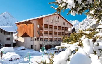
It's not too late to book an end of season ski getaway with Alpine Elements! Why not stay in Meribel, the second largest resort in Europe, at the beautifully situated, Chalet Himalaya for as little as £630pp for 7 nights, beginning the 18th March? Package also includes half-board catering, flights and transfers!
BOOK NOW
![]()